
The Cordillera Abitagua, first line of mountains facing the Amazon basin. Photo taken from my house in Banos high in the Andes, far to the west. A solid bank of clouds from the Amazon basin flows over the peaks of the Cordillera Abitagua; these are the habitats of its unique orchids. Photo: Lou Jost/EcoMinga.
In my previous post I talked about the way orchids dominate the endemic flora of Ecuador, and about some of the biological reasons for their diversity and local endemism. In this post I will give some examples from EcoMinga’s focal area illustrating just how fussy some of these endemic orchids can be about their habitat.
Our main focal area, the upper Rio Pastaza watershed, is a remarkable place with more locally endemic plant species (those found only in this watershed and nowhere else in the world) than the famous Galapagos Islands, even though the upper Rio Pastaza watershed covers a much smaller area than the Galapagos. About half of our local endemics are orchid species, mostly in the hyper-diverse genus Lepanthes, which I discussed in my last post, and the genus Teagueia, which I discussed in an earlier post.

The upper Rio Pastaza watershed, my study area. Map: Lou Jost/EcoMinga.
Over the last twenty years I’ve tried to map the distributions of these two genera in our area. I was very surprised by the narrow distributions of most of our Lepanthes species. For example, I found Lepanthes ruthiana only in a thin north-south strip along the foot of the first line of mountains facing the Amazon:

Lepanthes ruthiana. Photo: Lou Jost/EcoMinga.

Distribution of Lepanthes ruthiana, a thin band at the foot of the first mountain range facing the Amazon basin. Map: Lou Jost/EcoMinga.
Here’s Lepanthes lophius and its distribution, another thin north-south band, but farther from the Amazon:

Lepanthes lophius. Photo: Lou Jost/EcoMinga.

And here is Lepanthes decurva and its distribution, a thin north-south band at high elevations on the western edge of my area:
Lepanthes decurva. Photo: Lou Jost/Ecominga.

Ranges of Lepanthes decurva and L. lophius. The range of Lepanthes decurva, like that of L. lophius is a narrow north-south band at a fixed elevation and fixed distance from the Amazon basin. Map: Lou Jost/EcoMinga.
Remember (see my last post) that orchid seeds are wind-dispersed and can travel long distances, so these patterns aren’t due to limitations of seed dispersal. Similar distribution patterns are found for many other orchids here.
I think the shape of these distributions is caused by the humid the east-to-west winds hitting successive mountain ranges perpendicular to the winds. When the winds hit the first mountain range and are pushed upward, the air cools and much of its water condenses out as fog and rain. Now a little less humid, those winds hit the next range, and drop more of their water. By the time they hit the third or fourth chain of mountains, there is not much water left to condense out. Hence the moisture gradient, and the differences between microclimates from one chain of mountains to the next as we go from east to west.

Wet winds come from the east (the Amazon Basin) and successively hit each north-south chain of mountains. Mountains at a given distance from the Amazon get about the same amount of rain. So orchids tend to be distributed in north-south bands, sharing species across the Rio Pastaza valley. Species tend not to be shared eastward or westward, because those mountains have different amounts of rain. Map: Lou Jost/EcoMinga.
This habitat specificity might seem like bad news for conservation. Do we have to conserve every little microclimate variation? That would be almost impossible. Luckily for conservationists, it turns out that the most localized and specialized endemic orchids tend to occur together in the same microhabitat. The Cordillera Abitagua in our study area is an excellent example of this (see photo at top of this post). Most of the locally endemic orchids occur on ridgelines (which get more air movement and mist than valley floors) in a narrow band of elevations from 1800m to 2300m. There appears to be some differentiation of species from ridge to ridge within that elevation band, but most of the endemic species seem to occur on ridgelines throughout that band. Our strategically-located Rio Zunac Reserve protects the lower parts of this elevation band, and the Los Llanganates National Park protects the upper part. (It’s worth noting that this section of the national park is not patrolled by park guards, so our reserve and our own guards also protect the park.)

The Cordillera Abitagua as seen from an observation point high above the Amazon basin, looking west towards the Pacific Ocean. The red outlines show our reserves. Best to click on the image and enlarge it.

Some orchid species unique to the Cordillera Abitagua, all living between 1700m and 2300m. Left to right within rows: Lepanthes abitaguae, L. pseudomucronata, Maxillaria sp. nov., Masdevallia delhierroi, L. spruceana, L. sp.nov., L. zunagensis, Dracula fuligifera, Neooreophilus viebrockianus, Scaphosepalum jostii, Trichosalpinx zunagensis, Teagueia zeus. To appreciate their details, click to enlarge. Photos: Lou Jost/EcoMinga
A similar but less diverse cluster of locally-endemic species (some of them sister species of the Cordillera Abitagua endemics) occurs on the next line of mountains westward, which include Cerro Candelaria and Cerro Mayordomo. These mountains are only about 10-15 km west of the Cordillera Abitagua but have quite different orchid floras, at least in the hyper-diverse genera like Lepanthes. We protect a fairly good subset of these endemic species in our Cerro Candelaria and Naturetrek Reserves. We are actively expanding these to include more of these endemic species.

Our reserves in the upper Rio Pastaza watershed. Click to enlarge.

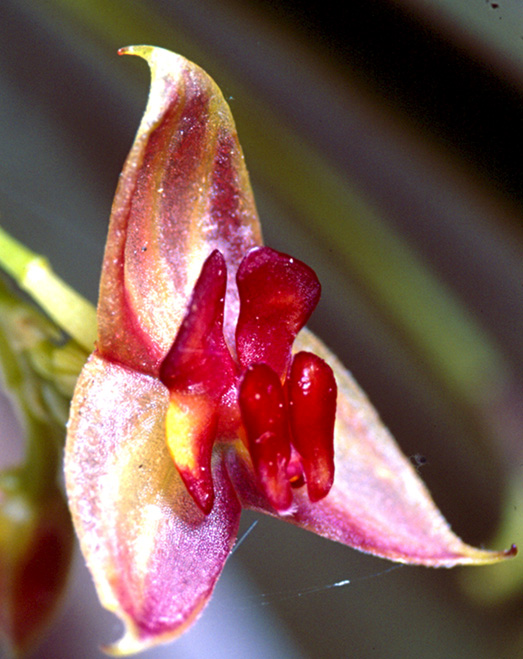
Lepanthes mayordomensis. Photo: Lou Jost/EcoMinga.
The next line mountains westward from Cerro Candelaria and Cerro Mayordomo also has a set of endemic species of Lepanthes, mostly at higher elevations. We have two small reserves in this range as well.

Lepanthes staatsiana, endemic to the next line of mountains to the west of Cerros Mayordomo and Candelaria. Photo: Lou Jost/EcoMinga.
This east-west climate gradient, and the corresponding changes in locally endemic species, pertain mostly to elevations below 3100m. Remarkably, something different seems to happen above that elevation. The Lepanthes species almost disappear, and they are replaced by another orchid genus, Teagueia, in the same subtribe (subtribe Pleurothallidinae). I’ve discussed this genus elsewhere. This genus has undergone an amazing local evolutionary radiation on the high mountaintops here, with about thirty locally endemic species, all new to science. Their distribution pattern is almost the opposite of the pattern shown by Lepanthes and related genera at lower elevations. Teagueia species, unlike Lepanthes, do not cross the valley of the Rio Pastaza, and this barrier seems to have been fairly effective even in the deep evolutionary past. These high-elevation Teagueia species also seem to have wider east-west distributions than the lower-elevation Lepanthes species.

We don’t understand why this high-elevation genus behaves so differently from the lower-elevation genera. But one clue may be provided by the crazy zigzag ash cloud of our local volcano, Tungurahua. Wind directions at different elevations can be wildly different, as this cloud reveals. Regardless of the reason for this pattern of distribution, we’ve been able to protect a very large part of this radiation in our Cerro Candelaria Reserve, which holds all 16 species that occur south of the Rio Pastaza, and we have protected another portion of this radiation in our Rio Valencia Reserve on the north side of the Rio Pastaza.

Complexity of wind and cloud formation is illustrated by this picture of our erupting Tungurahua volcano. Strong surface winds are coming from the left, pushing the ash cloud (which emerged from near the top of the volcano) to the right. Then, as the ash cloud rose, it reached a layer of air moving more slowly to the right. Then it hit a higher layer of relatively calm air and went straight up, until hitting a layer of air moving strongly from right to left. Then the ash cloud reached a layer of calm air and began to billow straight up.
In contrast the lenticular cloud of water vapor covering the volcano’s summit is in dynamic equilibrium, giving the appearance of not moving, in spite of the surface winds. It is constantly being created on its leading (left) edge and destroyed on its trailing edge. Photo: Lou Jost/EcoMinga.
Stay tuned for the next section of this talk in a few days…..
Lou Jost
And I hope you consider donating to EcoMinga’s fund for our reserves!

wau, really interesting!, regards from lima, peru
Pingback: Endemic Orchids Part 3: Priority areas for conservation. From a conference on endemic plants of Ecuador, Yachay, Ecuador, June 24-26, 2015. | Fundacion EcoMinga